National
UGANDA: ACHOLI LILICENTIOUS CULTURAL REVIVAL OF POST LRA-CHIEF JUSTICE OWINY-DOLLO
The Nazi style IDP camps in northern Uganda was characterized as follow.
The jungle law takes tools in Acholi Sub Region, as the most viable hardworking.
community who used to shun lawlessness, vagrants before the advent of British Colonialism. Now facing cultural decadent as youths, husbands and wives resort to ill cites.
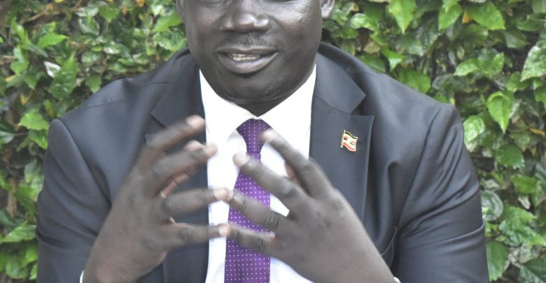
Chief Justice Alfonse Owiny-Dollo Cigamoi and the Former Ambassador, Dr. Prof
Olara Otunnu moves to revamp broken Acholi traditional cultural norms which has been.
destroyed during over two decades, the long conflict between Lord Resistance
Army and Uganda People Defense Forces (UPDF), when president Yoweri Museveni, the Commander In-chief of UPDF gave 48 hours ultimatum for the Acholi community to evacuates their homestead and moves to concentration camps.
“The 48 hours’ ultimatum which was issued in 2003 to the Acholi community to evacuate their villages was part of President Museveni schemed to alienated Acholi community, by earth to scorch fifth calumnious quelling Northern Uganda rebellion commanded by Joseph Kony led rebellion under Lord Resistance Army” political commentator asserted.
over 1,8 million population of Acholi who were forced in Nazi to eliminate individuals and small, targeted groups of individuals by murder, away from the public and judicial review by regime chronic.
GULU CITY- TUESDAY, October 24, 2023.
Chief Justice, Alfonse Owiny-Dollo Cigamoi and the former Ambassador, Prof.
Dr. Olara Otunnu they are embarking on licentious Acholi cultural revival after Kampala regime dismantle rich Acholi cultural heritage for over two decades.
This has been the worst Uganda history which has registered human suffering that has been eroded during 20 years’ conflict in Northern Uganda Internal Displaced Camps.
According to a UN report by Under Secretary England Young for Children Affairs indicated that, at the height of Uganda’s civil war, more than 1,000 Acholi had been. dying a week in concentration camps- more deaths than Darfur, or Iraq in 2005. The international community was being fed by Kampala regime misinformation and propagandist to hoodwink them, it was Lord Resistance Army LRA who had been forcing Acholi community into IDP camps, whereby the catastrophic condition of modern slavery, miming mutilation occurred with impunity.
Since rag thugs of LRA had failed to put up anti misinformation and National Resistance Army, NRA, President Museveni guerrilla who shoot their way to power in 1986, when the then Uganda Military Junta regime led by Gen. Tito Okello Lutwa his former Tanzania friend welcome him in 1985 after toppled Uganda People Congress Party UPC, the Obote government.
“Disease, malnutrition and mistreatment had hit 1.8 million Acholi internally. displaced from the countryside since Yoweri Museveni’s National Resistance Army had seized power, in the capital Kampala, in January 1986, Sweeping North and slaughtering Acholi civilians sparked three rebellions, the last being Joseph. Kony’s Lord’s Resistance Army.”
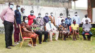
David Otto Labeja, the former Don of Gulu University, a translator for International Criminal Court, ICC, former editor Mega FM fourth night ago welcome the icons Chief Justice Owiny-Dollo and former Amb Dr. Olara Otunnu to appear on Radio MEGA FM talks shows in Gulu City.
Otto Labeja suggested that in Acholi when you have big dram, you let them sound he had been delegated for a mission to organize such an event.
Chief Justice Owiny-Dollo during his address, says his message is targeting clan leaders (Ludito Kaka me dog-gola), he is sorry to what is happening in Acholi Sub Region in regard to cultural norms which has become a catastrophic phenomenon, describing it as we call social evil.
“My message is for clans’ members and all the leadership in Acholi. community is about cultural breakdown, (Too Paco pa Acholi) what happening in Acholi Sub Region, today Acholi people women stand at dawn with bottle of beer in their hand shout with joy the ululation (Ki kijera ni ni lili lili) what a mess?”
This is not the first time for me to talk about cultural decay, we have been moving and talking in various platform in many funeral rite functions, citing places like Padibbe chiefdom, Puranga chef, and Koch chiefdom among other. But our people do not listen to our messages. Explaining that they have been moving with Dr. Olara Otunnu, and when he came to me and says, we cannot look at the
current deplorable cultural norms in Acholi, we cannot do somethings, or we look the other way.
“Pe wa twero neno to paco calo lwango ma tye iwang bur.” We have to do. something to revamp the way our women, youth, and men are behaving.” The Acholi of today they have never experienced such kind of life because when they were growing up, parents had full control of society.
The Acholi younger generation who was born during President Idi Amin era, never saw the real life of the Acholi as we were growing in 1950 and 1960s. Acholi of those day had a settled homestead, where there was no cultural breakdown life full was of prosperity. Citing kids who have been born during the post President Amin’s, the 1979 have forced and changed the society to adopt the liberation war, and culture of Tanzania Defense Forces and the lives Uganda Refugees who had experienced hard lives in Tanzania, Uganda National Liberation Forces who had suffered a lot in exile living in camps.” C.J reasoning.
Chief Justice Owiny-Dollo reasoned that when their father came back from Second world war, they had seen development form. the countries where they have fought from. Those second world war veterans had in their mind to start private secondary school.
Our father, the former World War II went and asked the people of Teso, Bugisu, Karamojong, Alur, Lubgwara and Madi communities to contributes money to begin private education school, they had determination to give Acholi children batter quality of education and they founded Sir, Samuel Baker in Gulu town which was regional district.
However, when Omugabi King of Ankole also heard that the second world war veterans founded their own private secondary school called Sir Samuel Baker Secondary school, they had to start Ntare Secondary school too.
Today there is no education in Acholi, Acholi who were second to East Mego in the in term of education when Uganda was achieving her independence in 1962, now a report by the government says Acholi has the least numbers of education in the country.
in 2o17 when Uganda bureau of Statistic UBS report realest Uganda poverty index, their report indicated that Acholi Sub Region is the poorest people in the country with the poverty index of 68 percent poorest second to the people Karamoja sub. region.
Today, our women and children find themselves working in the garden, while our youths and men are drinking Tolero waragi in the center.
The worst thing Acholi people are engaged in land conflict with his sisters, nephews, half-brothers and cousin. brothers, what a shame are the Acholi of today.
When my elder brother Dr. Olara Otunnu whispered and came to me in January, we organized for the meeting at my residence, many people came, some of them were from Lamwo district, while somebody boarded a bus from Nairobi to come and attend the meeting in my place. We have realized that we could discuss. To Paco pa Acholi. Now my appeals for the Acholi to your community, my appeals to the elders, and clan’s leaders Ludito Kaka to address cultural decadent.
Before we go to the government to ask for assistance, we must restore the cultural norms breakdown, not to see Acholi women drink at dawn, in the past you cannot. see Acholi women holding battle of bear, or waragi and youths being engaged in social evil like drinking waragi. What we used to drink was local brewing like Kwete, which was served during independent days and Christmas days where you.see men and women would be blessed to hold drinks.
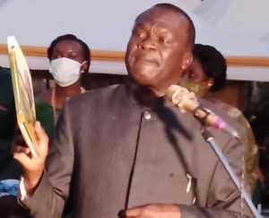
Dr. Olara Otunnu, narratives explore clans elder, Ludito Kaka to hold dignity and cherish to manage to control their individual’s clans. Today we have come with me. brother Chief Justice Owiny-Dollo to talk to your youths, our mothers and Acholi and men.
In Acholi we have Rwodi and clan’s leaders who have control over the affairs of their clan, we are appealing to clan leaders to listen to what we are saying, because. you are the back born custodian of your clans.
Also, I want to say why the particular tribes can be identified by Adaa pa Acholi ki Lutela maber, literally truthfulness, and honesty of the tribe and steward.
leadership, to guard against thieves. If Acholi has embraced those character, then we shall be Acholi in the past who had known. Acholi now are at the bottom of the hole. What can show that we have lost us?
cultural norms, Acholi now have been condemned to Alcoholism, when you take a move to part of Acholi Sub Region Acholi, you will only find women and their children gigging productive work in their garden, this can confirm what Chief Justice Owiny-Dollo says men and youth. Those guys are engaged in heavy drinking, what a shame.
In Acholi we are now fearing (Agwok) abomination, but today Acholi people just go and steal Simsim of his neighbor with impunity, in the past Groundnut used to be dry. to harvest from the garden, but today you have to carry it to your place.
Acholi people who were described by the British colonial master as having found a tribe. which had now crimes, there are no bagger, thief and destitute amidst them? community, now turn to be alighting stocks. I know our people are being killed by our enemies, but when time comes those. issues will be sorted out. Time will come when all those things can be answerable.
what for.
Now Acholi people do not believe in one another, they are engaging in land conflict. with their relatives, but the worst things, Acholi is calling the people who. employed or work for them like Lalaonyo reach man, his fellow Acholi brothers. and sisters.
Acholi have witnessed the worst calamity in their life, we must fight it out, we must be exemplary. Our vision should be for the long term, not medium term. My appeals go to the youths, the clan leaders and cultural leaders and religious leaders, we must unite to fight this vision called Paco. We have Acholi problems, poverty, laziness, not following Acholi cultural belief. and norms, majority of Acholi chiefs are younger generation, people of this day.
believe in money. Wycliff, one of the youths engaged in Bees keeping in Kitgum district says we need. to involve you in the current debate calls by Chief Justice Owiny-Dollo and Dr. Olara Otunnu. Youth should be the solution to revamping cultural beliefs and norms. Rosalba Oywa7 years old, one of the popular Mega Talks shows commented on our roles as the back born of Acholi people, we had leadership in our household. The father and our mother are the head of family structure. We have leaders when. we grew up, I did not know Rwodi because they were not there.
The roles of women were to feed the entire family, unity in family, unity in the family, what we called community farming work groups farms, our mother was. responsible with the informal education of girls up bring, in domestic core, while. men were responsible with boys up bring and economic well-being.
Acholi women were responsible for teaching their girls to prepare for the marriage,
the girls are ready for marrying, boys would call to pay homage to them. What? Acholi called (Lwongo), where boys physically appeared according to pre. appointment at in-law place.
Then later, the girl will escort him outside the homestead, whereby that boy will. introduce his agenda that he wanted to marry the girl, but instantly they will say no, until the boy proves to the girls, this will take a while, unlike today Acholi girls has. resorted to phones calls, you find that this day Acholi girls will have sex with lover.
to be without even knowing the name of the person. Major David Amone, the former Bodyguard of President Museveni who is author. Of Parish Development Model, asked he made call during Mega FM radio asking Dr. Olara Otunnu and Chief Justice Owiny-Dollo that how can we Acholi profit from patriotism and pan African as Acholi community.
The claims Dr. Olara Otunnu responded that, first they are still investigating the root causes for cultural norms breakdown holistically and if possible, Acholi will have developed technology as part of global mechanism, initiating economic. strategic plan which is headed by Prof. Kinyera Obwoya and his vice National. planning Anthony Odoch Langoya they will have developed Acholi Agenda.
Plan to which involve include economic policy, Doro paco that is monitoring. socoi-political and economic framework me neno kwo pa dano odok cen, to see. that Acholi cultural behavior is restored back. We have met many groups including.
Acholi Religious Peace Initiative, Wang OO Group, Gulu University as part of us
moves to put Acholi Agenda forward. Chief Justice Owiny-Dollo appeals to each household in Acholi Sub Region to plant three acres of Cassavas, potatoes, millet to avoid famine that may affect us community.
Chief Justice Owiny-Dollo concluded that, wan Acholi watye kaneno awang mac, we are only addressing the symptom of the problems, that is why we need to come. out. Warns that the current Balaalo confusion will derail us to solve real issues.